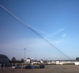
While the title of this post is “How to Debunk Chemtrails”, the actual debunking depends on what version of the theory needs debunking. The most common version is simply that “normal” contrails should not persist, so the persistent trails must be “chemtrails”. The simplest way to debunk this...
Continue reading
June 5, 2011 Mick West
contrails
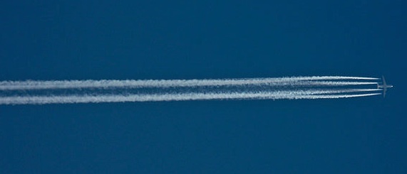
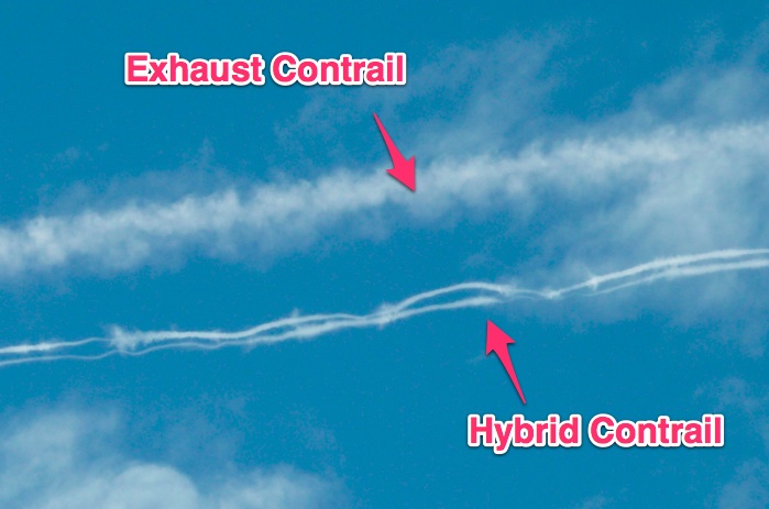
Contrails are generally classified into two types. Exhaust contrails and aerodynamic contrails. Exhaust contrails are formed by the mixing of the hot humid exhaust of the engines with cold humid surrounding air, creating long streamers of clouds. If the conditions are right then these can persist and spread. These are...
Continue reading
March 5, 2013 Mick West
contrails
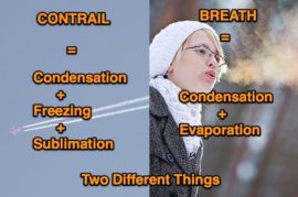
The trails that aircraft leave in the sky are called “contrails”, which is short for “condensation trails”. They are formed by the condensation of the water vapor in the aircraft exhaust. When you breathe out on a cold day, you see a little cloud of condensation form from...
Continue reading
December 13, 2012 Mick West
contrails
When you look up in the sky and you see a contrail, how far away is it? How far away are these contrails, a mile? two miles? Would you believe they are actually 20 to 100 miles away? Contrails typically form above 30,000 feet, or around six to...
Continue reading
November 5, 2012 Mick West
contrails
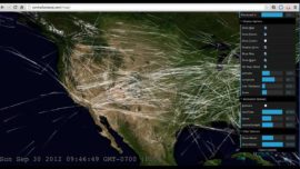
This link here will take you to the interactive map, but I suggest you first watch the video below which explains how it works (but watch it full screen, in HD), or look at some rather nice visualizations here. And to the point, here’s the worldwide distribution of...
Continue reading
October 28, 2012 Mick West
contrails
Contrails are the white lines that sometimes form behind high flying aircraft. They are actually a type of cloud. The cloud forms because jet exhaust contains quite a bit of water. If the humidity is high, then the contrails can persist for a long time, as clouds do....
Continue reading
September 29, 2012 Mick West
contrails
Contrails are the white trails that planes leave in the sky. They are a type of cloud and are comprised of very fine ice crystals, like a cirrus cloud. If the air at high altitude is humid, then the contrail will continue to accrete ice and can spread...
Continue reading
July 31, 2012 Mick West
contrails, science
References: Geoengineering covers lots of different things, not just spraying things from planes http://en.wikipedia.org/wiki/Geoengineering KSLA Report, debunked and retracted https://contrailscience.com/barium-chemtrails/ Chaff is a real thing and shows up on the weather http://www.crh.noaa.gov/lmk/?n=chaff-jan2006 But that’s a video of an aerodynamic contrail: https://contrailscience.com/aerodynamic-and-rainbow-contrails/ Contrails can persist and spread: https://contrailscience.com/persisting-and-spreading-contrails/ Levels...
Continue reading
February 5, 2012 Mick West
contrails
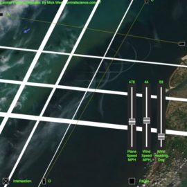
One often gets satellite images of contrails and it’s hard to visualize what’s going on, especially with racetrack contrails drifting in the wind. So I wrote a little contrail simulator applet to demonstrate the formation of a contrail under various conditions.
Continue reading
January 19, 2012 Mick West
contrails
When did you first see contrails?
Continue reading
January 6, 2012 Mick West
contrails
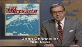
This news report is from 1980. It’s based on this research paper: EFFECT OF CONTRAIL CIRRUS ON SURFACE WEATHER CONDITIONS IN THE MIDWEST (Searchable/Copyable OCR version here) It’s interesting because it shows that back in 1980 people were noticing contrails persisting and spreading to cover the whole sky. At...
Continue reading
December 1, 2011 Mick West
contrails
Several contrails show up in this amazing video sequence of a full year of days shown simultaneously. A History of the Sky
Continue reading
November 26, 2011 Mick West
contrails
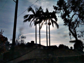
It’s a lovely Friday morning here in Los Angeles. Clear blue skies, not a cloud to be seen, and no contrails either. For that matter, there don’t appear to be any planes at all. I look up into the clear deep blue sky, and I can’t see a...
Continue reading
July 1, 2011 Mick West
contrails
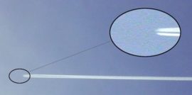
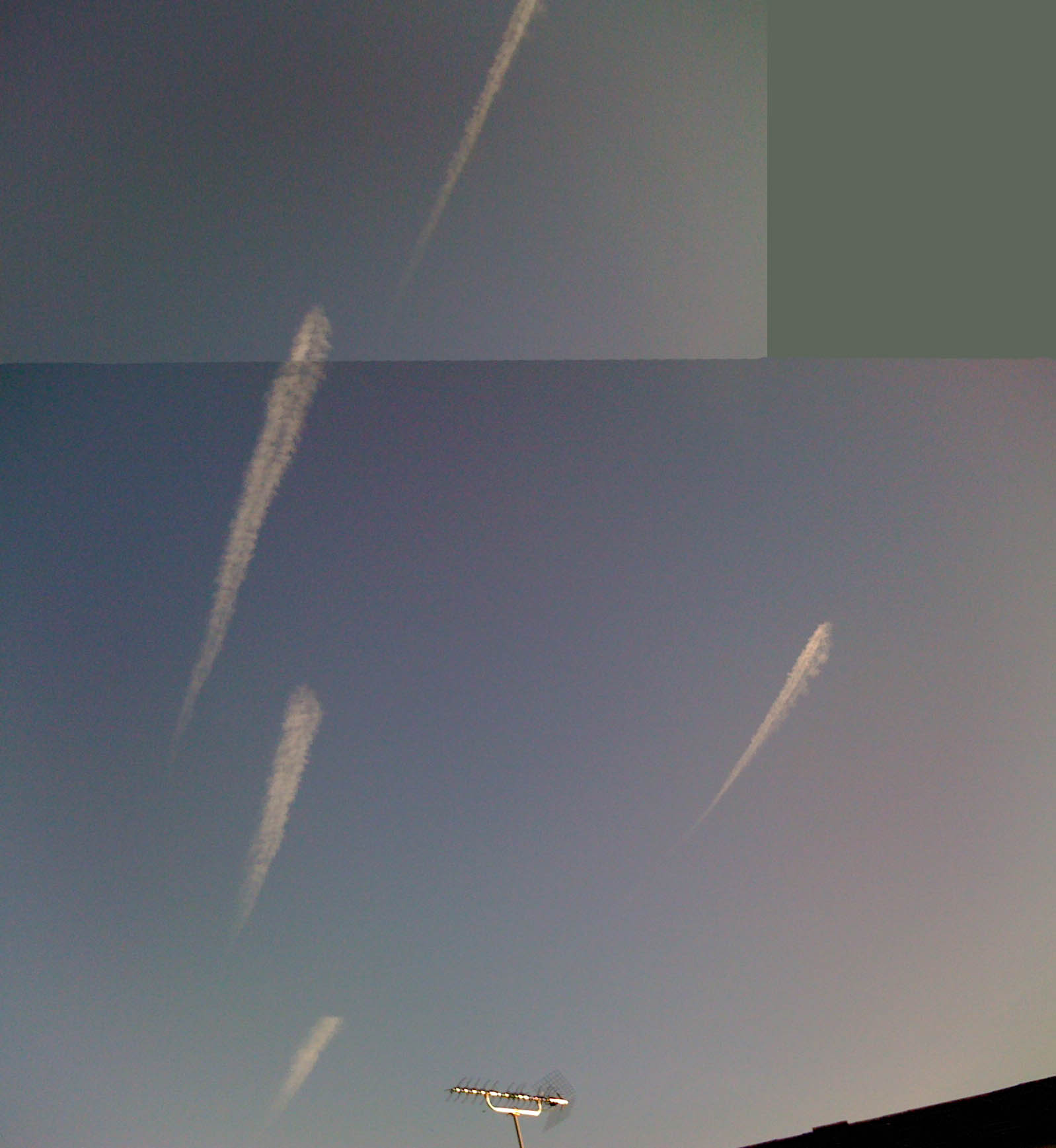
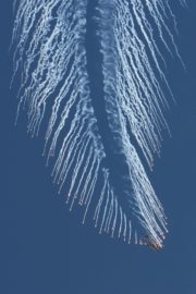
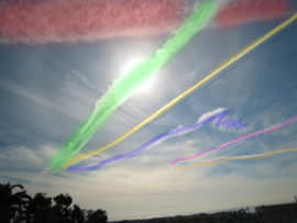
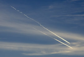
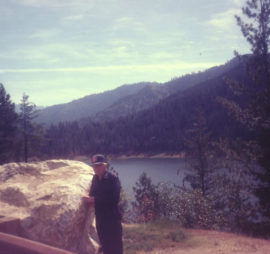
UK resident UnionJack1967 recently posted some photos on DavidIcke.com of five very unusual looking trails. He took several photos, and I’ve combined two of them here to show all five trails together.
Continue reading
April 17, 2011 Mick West
contrails
Sometimes planes leave contrails, and sometimes they don’t. It depends on the weather, and specifically, it depends on the weather at altitude. It’s also very localized. A plane might leave a trail in one region, and another plane a mile away might not leave a trail. NASA have...
Continue reading
March 21, 2011 Mick West
contrails
There are more contrails now than there were 20 or 30 years ago because there are a lot more flights now. But it’s not entirely that simple. As well as more frequent flights, there are more routes. Areas that almost never saw a contrail would suddenly start seeing...
Continue reading
March 9, 2011 Mick West
contrails
This is a remarkably common news story: It’s just after sunset, someone looks towards the west and they see the short contrail of a jet plane illuminated by the sun. It looks red, like fire. They zoom in with their video camera. They don’t know what it...
Continue reading
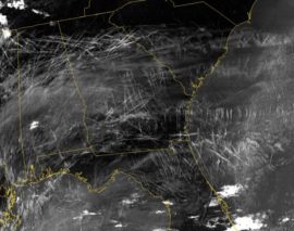
February 13, 2011 Mick West
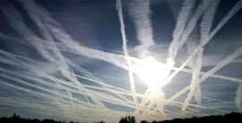
contrails
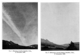
One very popular photo amongst the “chemtrail” theorists is this one from NASA: The image is quite striking, showing a very large number of contrails over an area five hundred miles wide. It’s an infrared image which has been enhanced specifically to bring out the contrails. This image has been...
Continue reading
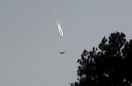
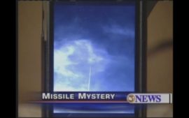
January 30, 2011 Mick West
contrails
This must be the least missile-like mystery-missile ever. Taken Sunday, Jan 2nd, 2011, at “about three in the afternoon. The video shows a jet contrail – barely moving relative to the clouds. It’s just a jet that happened to fly directly overhead, so the approaching contrail looks vertical....
Continue reading
January 5, 2011 Mick West
contrails
No. In all likelihood, the birds’ death had a quite normal explanation. The weather. See my full article here: http://metabunk.org/content/134-Dead-Blackbirds-Fall-From-Sky-Prompting-Bunk and another of the media coverage, with links to some more examples of mass bird deaths. http://metabunk.org/content/137-Dead-Bird-Panic-How-Media-Focus-Distorts-a-Subject But if you really want to go down the “chemtrail” route....
Continue reading
January 3, 2011 Mick West
contrails
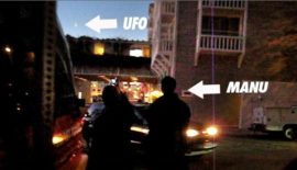
CASE CLOSED: It was Red Bull Air Force! Update: Here’s the google earth file I was forwarded an interesting video on TMZ a few days ago: http://www.tmz.com/2010/12/09/manu-ginobili-ufo-video-san-antonio-spurs/ It shows Manu Ginobili of the San Antonio Spurs as he observes some kind of UFO in the sky behind him....
Continue reading
December 11, 2010 Mick West
contrails
[Update] Download the Google Earth files used to make some of the images below, and judge for yourself (or show your friends). There’s a video to show you how.
Continue reading
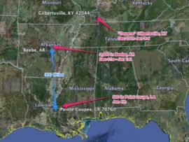
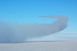
November 13, 2010 Mick West
contrails
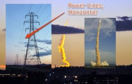
I think the one thing that prevented most people from seeing the supposed “missile” trail as what it was (a jet contrail, almost certainly from flight UPS902 from Hawaii), was the illusion that it looked like it was going straight up. Compare one photo of the 902 trail...
Continue reading
November 12, 2010 Mick West
contrails
UPDATE – After getting a new photo of the trail, Liam Bahneman told me he was now siding with it being his second choice, UPS902. Having reviewed the evidence, I fully agree that UPS902 is a much better fit than AWE808, especially when viewed against the composite photo.
Continue reading
November 9, 2010 Mick West
contrails
Update: If you are looking for a debunking of Why In The World Are They Spraying, first check out this post, as the second film really depends on the first being true, then have a look at the various errors in Why In The World Are They Spraying, detailed...
Continue reading
October 26, 2010 Mick West
contrails
Most of the supposed “chemtrail” videos out there are simply videos of persistent contrails that the video maker somehow has decided are part of a giant world-wide conspiracy involving spraying something for some purpose. But some videos are actually deliberate hoaxes, either by pranksters poking fun at the...
Continue reading
July 24, 2010 Mick West
contrails
Most of the traffic to this site comes via Google and other search engines. It’s interesting to look at what people typed in to that ended up here. Quite often it’s just a few words like “chemtrail aircraft pictures” or “contrails engine”, but sometimes it’s a question. I...
Continue reading
June 9, 2010 Mick West
contrails
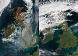
The cloud of volcanic ash from Eyjafjallajökull has prompted the most significant air-traffic shutdown in European history. This will provide a unique opportunity to study the effects of a contrail-less sky. But we must be careful how quickly we draw conclusions from the immediate data. Take the two images above, the...
Continue reading
April 18, 2010 Mick West
contrails
Some planes in the sky leave trails that persist and spread, and other planes, in the same sky, leave short-lived trails, or no trails at all. These trails are actually called contrails, short for “condensation trails”. They are not smoke from the engines, they are formed when the...
Continue reading
March 5, 2010 Mick West
contrails
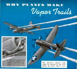
Popular Science, March 1943. Page 55. While this applies to 1943 planes, it should also be noted that the exact same mechanisms are responsible for contrails from modern jet aircraft. Jet engines burn fuel that is essentially the same kind of chemical as used by old prop planes....
Continue reading
February 8, 2010 Mick West
contrails
I took this photo this morning: It’s an interesting contrail as most trails you see are straight lines, planes generally fly directly from one place to another. This plane was flying in a south east direction. After making this left turn it made a right turn to continue...
Continue reading
January 3, 2010 Mick West
contrails
For a contrail enthusiast, I picked the wrong place to live. We hardly ever get persistent contrails here in the summer, but things have been picking up a bit as we go into fall, and today we had this: A very nice triple set of contrails of three...
Continue reading
October 26, 2009 Mick West
contrails
(The following was written as a comment by “boenoid”, but I thought it was interesting enough to deserve its own post. I (Mick) have added the assembly line image) For what it is worth, I am a Boeing engineer with 20 years of experience in the aerospace industry....
Continue reading
September 25, 2009 Mick West
contrails
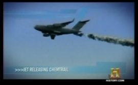
Well, it looks like the cat is out the bag. The secret government has slipped up and allowed the release of a History Channel special that spills the beans on the whole Chemtrail program! Several clips from this show are available on youtube: The unfortunate thing about the...
Continue reading
July 25, 2009 Mick West
contrails
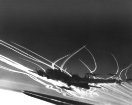
Not a contrail, but a nice image: A U.S. Air Force AC-130 Gunship aircraft executes an evasive maneuver and drops chaff and flares during a firepower demonstration at the Nevada Test and Training Range in Nevada on Sept. 14, 2007. http://www.defenselink.mil/photos/newsphoto.aspx?newsphotoid=9540 I don’t know if you can actually...
Continue reading
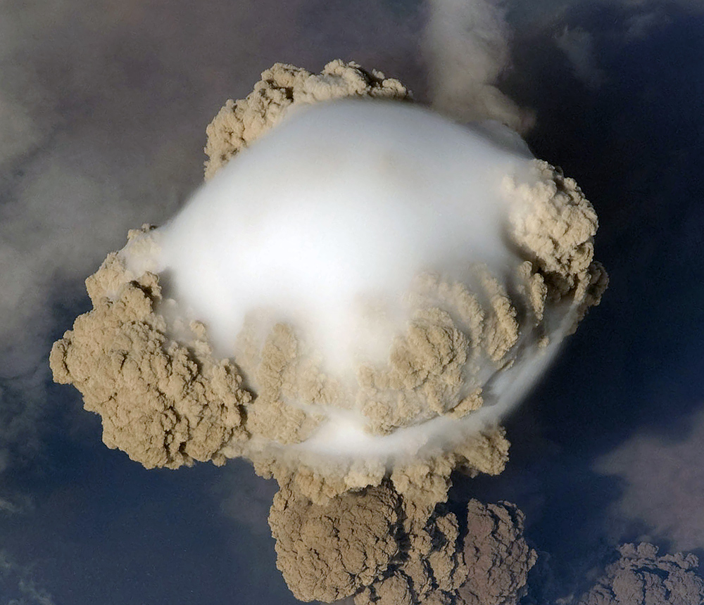
July 21, 2009 Mick West
contrails
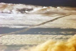
Okay, it’s not actually a contrail. But it’s a related phenomenon – a plume of hot humid air is rising from a volcano, and where it hits the cold upper air, the water vapor it contains condenses out. Possibly into ice, but it’s hard to tell. The brown...
Continue reading
June 23, 2009 Mick West
contrails
This photo is from January 29th 2009, at approximately 3-4PM over Corvallis, Oregon. It shows a contrail from a plane that has made a 540 degree turn (one and half full turns) to fly back the way it came. This photo was probably taken an hour after the...
Continue reading
May 16, 2009 Mick West
contrails
Contrails form when the water in engine exhaust mixes with cold moist air and freezes. Normally you see this at 30,000 feet with jet engine exhaust. But in some parts of the world, these conditions can be found at ground level. Here’s a car leaving a contrail in...
Continue reading
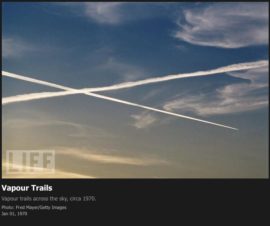
May 4, 2009 Mick West
contrails
[UPDATE: Some of these photos are now available again with a “personal non-commercial use” licence via Google. http://images.google.com/hosted/life The following images were all found on the Life Magazine web site. Originally they linked to the page on Life where the photo could be ordered, but Life has since...
Continue reading
April 24, 2009 Mick West
contrails
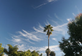
I took these photos around 8AM this morning, Feb 4th 2009, in Los Angeles. They show Cirrus Uncinus clouds, with a contrail running through them. Cirrus uncinus clouds (or “Mares’ Tails”), according to wikipedia: Cirrus uncinus is a type of cirrus cloud. The name cirrus uncinus is derived from Latin, meaning “curly hooks”....
Continue reading
February 4, 2009 Mick West
contrails
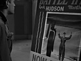
I was watching the first episode of The Twilight Zone, Where is Everybody, made in 1959, and I noticed that the movie poster had a nice depiction of some persistent contrails forming a grid: I don’t think it’s a real poster, but it’s a real movie (Battle Hymn,...
Continue reading
January 2, 2009 Mick West
contrails
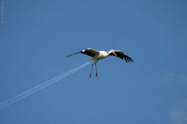
This is an actual photo, not photoshopped. The stork is not at the same altitude as the contrail, it’s actually quite a bit lower. It’s the same thing when you see two planes, one making a contrail, and one not – they are just at different altitudes.
Continue reading
December 4, 2008 Mick West
contrails
I was walking along this morning at around 10AM, when I noticed a huge semi circular contrail, somewhere to the south of LAX. This is something I’ve never seen before. The weather was very well suited for contrails, and there were quite a few criss-crossing the sky. Then...
Continue reading
November 20, 2008 Mick West
contrails
I find clouds fascinating. If I see a lenticular cloud while driving I might nearly crash the car while straining for a better view. I’ve only seen mammatus clouds once in my life, and stopped to try to take a photo. I’m quite fascinated by contrails...
Continue reading
November 18, 2008 Mick West
contrails
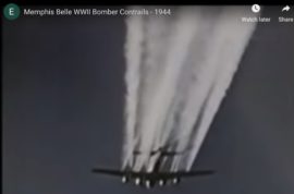
This is an excerpt from the 1944 film “The Memphis Belle: A Story of a Flying Fortress”. The full original film is public domain, and can be found here: http://www.archive.org/details/TheMem… The film shows contrail formation, including showing “broken” contrails. http://www.youtube.com/watch?v=wfOrez6q7WM Make sure you listent to the audio, as...
Continue reading
November 3, 2008 Mick West
contrails
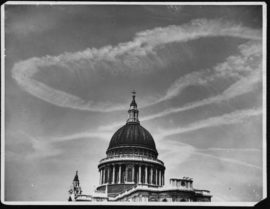
Contrails are a common sight now, but prior to the advent of commercial jet travel in the late 50s, there was little reason for planes to fly high enough to form contrails. However, during the Second World War, high altitude aerial dogfights over the UK were quite common....
Continue reading
October 26, 2008 Mick West
contrails
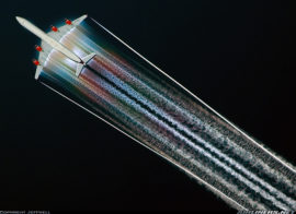
You occasionally see very pretty photos of contrails, like this one: Very pretty. But what is it? It’s clearly not a regular exhaust contrail, as the trail seems to start actually ON the wing, and it has a weird rainbow effect you don’t often find in exhaust contrails....
Continue reading
August 24, 2008 Mick West
contrails
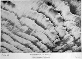
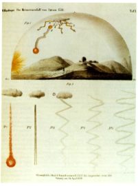
The book “Cloud Studies” was published in 1905, over a hundred years ago. It was written by Arthur W. Clayden, M.A., Former principal of University College, Exeter, UK. The book is available in PDF form since it’s out of copyright: https://contrailscience.com/files/Cloud_Studies.pdf But the images are rather low quality,...
Continue reading
August 18, 2008 Mick West
contrails
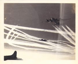
There are lots of photos of contrails from World War II. I’ve collected a few of them here: https://plus.google.com/photos/107393796095434664991/albums/5235534135256807809 The collection shows all types of contrail formation – from the very short ones, to long persistent trails that spread out like cloud cover. Why so many photos of...
Continue reading
August 16, 2008 Mick West
contrails
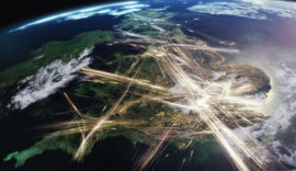
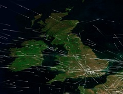
There’s a great new series on the BBC in the UK: Britain From Above, that shows how various things look from a high perspective, using very interesting visualization techniques. One of the most interesting (for me) was an episode that showed all the air traffic in UK airspace...
Continue reading
August 11, 2008 Mick West
contrails
Contrails are long thin clouds of ice crystals that form behind planes that fly through freezing cold air. Usually, you see them behind jets at around 30,000 feet. If the air they fly though has enough moisture in it already, then these contrail clouds can last for...
Continue reading
August 1, 2008 Mick West
contrails, science
I’m very interested in contrails, but when you look for information about them on the internet, half the sites that turn up are about a conspiracy theory which claims that any trail that last more than a few minutes is actually a “chemtrail”, comprised of dangerous chemicals, particularly...
Continue reading
June 6, 2008 Mick West
contrails
This photo has the largest number of contrails I’ve seen in a single photo: There seem to be at least 30, possibly more (click the photo for a larger verision). What is even more remarkable is that it was taken sometime before 1967. That’s over forty years ago....
Continue reading
March 17, 2008 Mick West
contrails
Another bit of “Chemtrail” mythology was born with this YouTube video: http://www.youtube.com/watch?v=FiUMfsR28SM This video has been seized upon by the Chemtrail community as evidence that “chemtrails” are real, and that the German government has admitted they are spraying “chemtrails”. Unfortunately the entire video is a very bad translation...
Continue reading
March 14, 2008 Mick West
contrails
Q) How long do contrails last? A) According to all the books on clouds in the last 70 years, contrails last anywhere from less than a second, up to several hours. If depends on the atmospheric conditions at the altitude the plane is flying. It’s unrelated to the...
Continue reading
February 26, 2008 Mick West
chemtrails, contrails, science
I took this photo on December 16, 2007, at around noon. It’s facing south from Los Angeles, California. It was a particularly good day for contrails. You can see about seven in this photo. There’s also a nice contrail shadow, and a halo around the sun. I was...
Continue reading
February 20, 2008 Mick West
contrails
Here’s a newly discovered photo of contrail in WWII, this was taken by William Anderson, and uploaded by a grandchild of his, here. ( Creative Commons, Some rights reserved) Update: The photo album has been updated with a much better scan: You can see it’s taken...
Continue reading
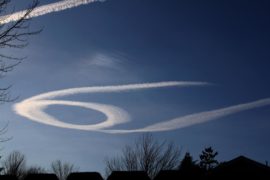
January 28, 2008 Mick West
contrails
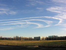
Here’s a contrail you don’t see every day: the racetrack contrail (or, as I like to call this one, the paperclip contrail) This photo was taken near Portland, Oregon on December 11th, 2005, at around 11AM. So why would a plane be flying in this unusual pattern? Well,...
Continue reading
January 21, 2008 Mick West
chemtrails, contrails
The Wright Brother’s first achieved powered flight in 1903. They only got a few feet off the ground, so of course did not leave a contrail. However it was barely more than a decade before planes inched into colder air, and the first reports began. The earliest known...
Continue reading
January 3, 2008 Mick West
chemtrails, contrails, science
I snapped this a few minutes ago, looking west from Santa Monica:
Continue reading
December 21, 2007 Mick West
contrails
It’s been interesting weather here in Los Angeles, as a couple of storm systems have rolled through we’ve had some days of nice looking clouds, and some days with lots of contrails. I snapped this one this morning: It shows a contrail from the lower left that then...
Continue reading
December 20, 2007 Mick West
contrails
Either by day or a little after sunset, in fine weather, a little, light, long-drawn cloud is seen, like a long very straight line. – Aristotle, Meteorologica, 340BC Not every long straight line in the sky is a contrail. Here Aristotle suggests it’s “a sort of wave-mark in...
Continue reading
December 12, 2007 Mick West
contrails
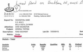
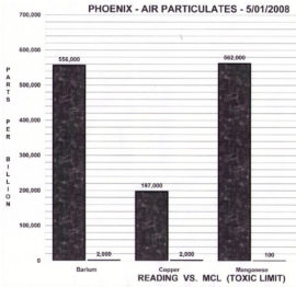
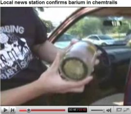
Brief Summary: Samples of water were collected in August 2007, in Stamps Arkansas, by leaving some bowls outside for a month The resultant dirty water was tested by KSLA and was found to have the same amount of barium in it as most municipal tap water. The reporter...
Continue reading
December 8, 2007 Mick West
chemtrails, contrails, science
Some people think that persistent spreading contrails are somehow unusual, and are actually something dangerous being deliberately sprayed on the US people by the government, or perhaps for weather control purposes. They call these persistent contrails “chemtrails”. Some of them are very insistent that this is a practically...
Continue reading
October 26, 2007 Mick West
chemtrails, contrails, science
I’ve talked about distrails and hole punch clouds before, but I’ve actually never seen one myself until this morning, when I saw two side by side. It’s quite rare to have this kind of weather condition in Los Angeles. I took a couple of photos at around 7:30AM...
Continue reading
August 19, 2007 Mick West
contrails
There was an interesting post over on the New York SkyWatch blog, which raised many of the common questions that people have about various contrail anomalies. I’ve attempted to answer all of the questions here: Question #1, why [do] jet contrails appear as if the jet engine is...
Continue reading
June 9, 2007 Mick West
contrails
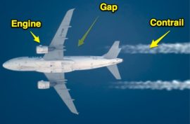
Contrails are clouds made from water vapor that condenses then freezes behind a plane engine. Since the engines are on constantly, it seems a bit odd when you see contrails with gaps in them, or even contrails that stop and start. If the engine is pumping out a...
Continue reading
June 8, 2007 Mick West
chemtrails, contrails, science
People who think persistent contrails indicate some kind of conspiracy (which they call “chemtrails”), sometimes point to the “dark lines” that sometimes accompany contrails. Since they can’t immediately think of why these dark lines should be there, they assume it’s part of the conspiracy. Either there is some...
Continue reading
June 4, 2007 Mick West
contrails, science
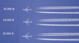
How high are those contrails? That’s a very important issue if you are investigating the science of contrail formation. I’ve been thinking for a while that a good method might be to take photos at a plane at a known focal length on a digital camera, and then...
Continue reading
May 29, 2007 Mick West
contrails
I’ve collected together a few photos of persistent spreading contrails from the past from 1991 back to 1940, just to show that this is nothing new, and that skies exactly like those shown on the “chemtrails” conspiracy web sites have been happening for the past 60 years. Mostly...
Continue reading
May 26, 2007 Mick West
Uncategorized
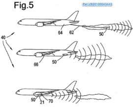
Several planes look a little odd, or have attachments that look odd, and so some people feel they must be part of a decades long conspiracy to spray stuff into the atmosphere to alter the weather or reduce the population. That’s obviously nonsense, but what are these strange...
Continue reading
May 23, 2007 Mick West
chemtrails
One of the more pervasive myths regarding “chemtrails” is that 2008 presidential hopeful Dennis Kuchinich tried to have them banned by an act of congress, but was pressured by the government to modify the act to remove the mention of “chemtrails”. So what really happened? In a nutshell,...
Continue reading
May 19, 2007 Mick West
contrails
I like these contrails from the movie Cars: They look a little odd at first, but if you look closely (click on the image to expand it) you can see they are actually tire tracks. Here’s some more pics, from a site that thinks the government had these...
Continue reading
May 18, 2007 Mick West
contrails
Some people believe that the government is spraying something into the air, and this creates unsual looking contrails. They call these “chemtrails”. Now, there is no real evidence that “chemtrails” are real, but there are several myths on the internet about “chemtrails”. All these myths can very easily...
Continue reading
May 18, 2007 Mick West
contrails
What is a contrail made of? Mostly ice, since one of the primary exhaust emissions of a jet aircraft is water vapour, which freezes within a couple of seconds, and forms the visible part of the contrail. If the air is fairly humid, then the contrail can persist...
Continue reading
May 15, 2007 Mick West
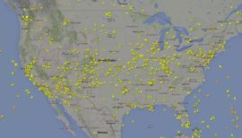
Uncategorized
There are a lot of planes in the air, several thousand at any given time over the US. This animation shows all the tracked air traffic in the air at once. Each dot is a jet. Click on the image to see a 24 hour animation The animation...
Continue reading
May 11, 2007 Mick West
Uncategorized
“Chemtrails” are supposedly long lasting contrails that are being deliberately created by the government for some sinister purpose. In reality, these contrails just look like normal contrails. It’s a fringe conspiracy theory that spread over the internet, mutating as it goes for survivability. But where did it begin?...
Continue reading
May 11, 2007 Mick West
Uncategorized
The opposite of a contrail is a “distrail”. When a jet flies through a high cloud then various factors to do with the passage of the jet are sufficient to trigger precipitation in the cloud, leaving holes or trails. The precipitation can spread outwards quite a distance. This is a...
Continue reading
May 9, 2007 Mick West
contrails, distrails
How many people are interested in chemtrails? Not very many I suspect. But how to measure them? One way is to see how popular they are on the internet. You could measure how many web pages mention “chemtrails”, but that could give a distorted picture, as the people...
Continue reading
May 8, 2007 Mick West
contrails
Some people think that persistent contrails (high altitude aircraft vapor trails) are unusual, and are evidence of some secret government plot to modify the weather, or spread some population controlling drug or toxin. This is based on a misunderstanding of how contrails form, persist and spread. It is...
Continue reading
May 6, 2007 Mick West
Uncategorized
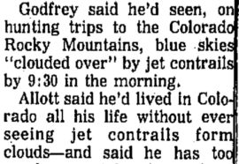
Some people believe that persistent contrails are evidence of a secret government spraying program called “chemtrails,” which began in the 1990s for some purpose, such as weather control, population control, or more exotic purposes. A common claim made by those believers is that chemtrails have persisted only in...
Continue reading
May 5, 2007 Mick West
Uncategorized
Do contrails sometimes persist and spread out? Yes, see the Encyclopædia Britannica article on vapour trails (contrails): Contrail, streamer of cloud sometimes observed behind an airplane flying in clear, cold, humid air. It forms upon condensation of the water vapour produced by the combustion of fuel in the...
Continue reading
May 4, 2007 Mick West
chemtrails, contrails, science